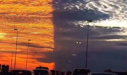
A visible cold front moving across Canyon Lake, Texas on a Sunday afternoon (December 7, 2025)
Title: Dramatic Cold Front Sweeps Canyon Lake, TX: Sunday Afternoon Weather Event Stuns Residents (Dec 7, 2025)
Meta Description: On December 7, 2025, a powerful cold front visibly swept across Canyon Lake, Texas. Learn how this dramatic weather event unfolded, its impacts, and safety tips for future fronts.
A Visible Cold Front Stuns Canyon Lake: December 7, 2025 Weather Event
Residents and visitors at Canyon Lake, Texas, witnessed a rare meteorological spectacle on Sunday afternoon, December 7, 2025, as a sharply defined cold front surged across the region. The dramatic shift brought rapid temperature drops, gusty winds, and a visible boundary in the sky—a phenomenon rarely seen in Central Texas. In this article, we break down the science behind the front, its local impacts, and how to prepare for similar events in the future.
The Day the Sky Split: A Front You Could See
Around 2:30–3:00 PM CST, observers reported a distinct, cloud-packed line moving southeast across Canyon Lake. Social media flooded with images of the front’s leading edge—a towering wall of clouds contrasting sharply with the clearer, warmer air ahead.
Key Features of the Front:
- Temperature Plunge: Temperatures dropped 15–20°F in under an hour, from a mild 68°F to the upper 40s by sunset.
- Gusty Winds: Northwest winds surged to 25–35 mph, whipping up whitecaps on Canyon Lake.
- Visibility: The front’s boundary was starkly visible from viewpoints like Overlook Park and Cranes Mill Park, resembling a slow-moving tsunami of clouds.
Why Was This Cold Front So Visible?
Cold fronts are common, but visual ones require specific conditions. Meteorologists attribute this event to:
- Dry Air Ahead: A dry, warm air mass allowed for clear skies before the front’s arrival, creating contrast.
- High Moisture Contrast: The front tapped into Gulf moisture, forming dense cumulus clouds at its edge.
- Perfect Timing: Midday sunlight illuminated the front’s structure, making it photogenic for onlookers.
Impacts on Canyon Lake & Surrounding Areas
1. Boating & Water Safety
The sudden winds caused dangerous conditions on Canyon Lake, prompting the U.S. Army Corps of Engineers to issue a temporary advisory for small boats. Fishermen near Indian Creek reported choppy waters forcing early dock returns.
2. Outdoor Plans Disrupted
Weekend hikers at Canyon Park Trail scrambled for cover as winds overturned picnic setups. Nearby, the Canyon Lake Gorge tour group canceled afternoon sessions.
3. Wildlife Activity
Birdwatchers noted unusual behavior, including flocks of geese fleeing south ahead of the front. Deer Movement spiked in Comal County woodlands hours prior—a sign animals sensed the pressure change.
Resident Reactions: “It Felt Like a Movie!”
Rebecca Torres, a Canyon Lake local, captured viral footage of the front from her porch: “One minute it was sunny, the next this massive cloud wall swallowed the lake. You could literally see the cold air rushing in!”
Meanwhile, staff at The Lighthouse Restaurant scrambled to secure patio furniture as winds gusted. “Tables flew like cardboard,” remarked manager Joe Alvarez.
How to Prepare for Future Cold Fronts in Central Texas
While this front caused no major damage, similar events can pose risks. Keep these tips in mind:
- Monitor Forecasts: Use apps like NOAA Weather Radar to track fronts in real-time.
- Secure Outdoor Gear: Patio furniture, boats, and holiday decorations can become projectiles in 30+ mph winds.
- Layer Up: Texas cold fronts bring rapid chill—always keep a jacket handy in late fall/winter.
- Avoid Water: Sudden wind shifts create treacherous waves. Postpone boating until conditions stabilize.
The Science Behind the Spectacle
Cold fronts occur when dense, cold air displaces warmer air, forcing it upward. This upward motion triggers cloud formation—and when humidity contrasts are high, the front becomes visible. The December 7 front was amplified by a strong jet stream dip over the Rockies, funneling Arctic air deep into Texas.
Looking Ahead: Canyon Lake Winter Weather Trends
The 2025 event underscores a trend toward more volatile fall/winter weather in Central Texas. Climate scientists suggest warmer Gulf waters may fuel sharper fronts. Locals should stay alert for:
- Flash freezes after wet fronts (risk of black ice on FM 306).
- Lake-effect fluctuations: Rapid temperature swings can stress lake ecosystems.
Final Thoughts
The December 7, 2025, cold front over Canyon Lake was a jaw-dropping reminder of nature’s power. While disruptive, it provided a unique opportunity to witness atmospheric dynamics firsthand. By staying informed and prepared, residents can safely enjoy—and even photograph—future weather wonders.
Target Keywords:
- Canyon Lake cold front
- Texas visible weather front
- December 2025 Texas weather
- Canyon Lake winter storms
- Cold front safety tips
Optimization Tips for Sharing:
- Share images/videos with hashtags: #CanyonLakeWeather #TXColdFront #StormChasing
- Link to local resources: National Weather Service Austin/San Antonio, Canyon Lake Emergency Alerts
For real-time Canyon Lake weather updates, bookmark the National Weather Service or follow Comal County OEM on social media. Stay safe and weather-aware! 🌪️🧥