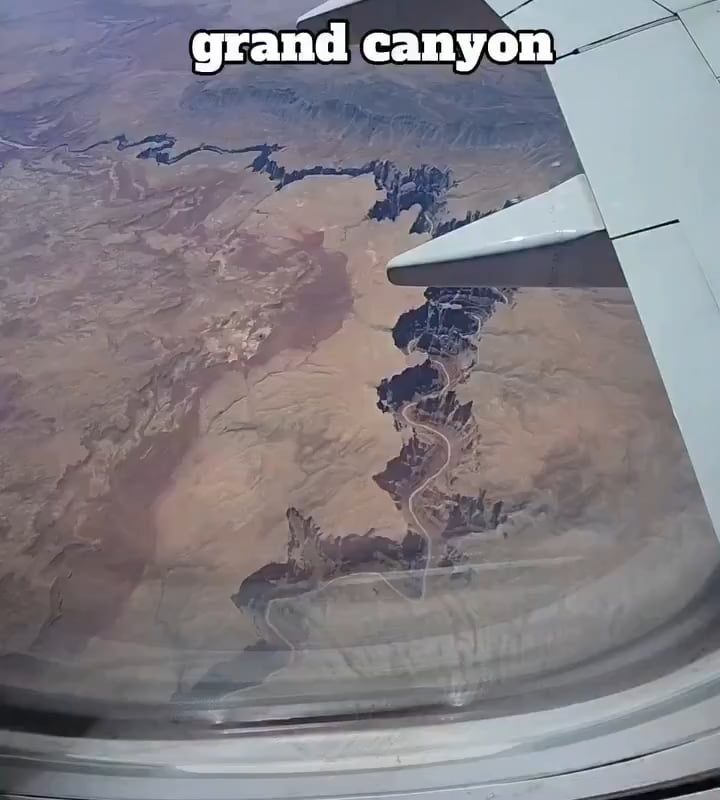
Aerial view of Grand Canyon in Arizona, showing the Colorado River’s erosion over millions of years.
Title: Soaring Above Time: How the Colorado River Sculpted the Grand Canyon Over Millions of Years
Meta Description: Explore the Grand Canyon’s breathtaking aerial views and learn how the Colorado River’s relentless erosion carved this natural wonder over millions of years. Plan your visit and uncover its geological secrets!
A Bird’s-Eye View of the Grand Canyon: Nature’s Masterpiece
An aerial view of the Grand Canyon reveals a sprawling labyrinth of rust-colored cliffs, deep gorges, and serpentine ridges stretching across 277 miles of Arizona’s high desert. From above, the canyon’s sheer scale becomes awe-inspiring—a testament to the relentless power of the Colorado River, which spent millions of years etching this geological marvel into the Earth’s crust. Helicopter tours and scenic flights offer visitors a chance to witness this epochal landscape, where layered rock formations tell a 1.8-billion-year-old story of planetary transformation.
The Colorado River: Architect of the Grand Canyon
The real star of this aerial spectacle isn’t just the canyon—it’s the Colorado River, the tireless force that carved it. Erosion began roughly 5–6 million years ago as tectonic uplift raised the Colorado Plateau, creating the gradient that accelerated the river’s flow. Armed with sediment and debris, the river downcut through layers of sedimentary rock at a rate of just 0.015 inches per year—yet over millennia, this persistence excavated a canyon up to 6,093 feet deep.
From the sky, the river’s winding path resembles a turquoise ribbon, contrasting starkly with the canyon’s fiery hues. Its journey weaves through rapids, waterfalls, and side canyons, each bend revealing new evidence of mechanical and chemical weathering:
- Hydraulic action pries rocks loose from cliffs.
- Abrasion from sediment “sandblasts” canyon walls.
- Decades of flash floods widen cracks into slot canyons.
A Timeline Written in Stone
The Grand Canyon’s walls—visible in astonishing detail from above—act as a geological timeline. Each stratum represents a distinct era:
- Kaibab Limestone (270 million years old): Forms the canyon’s rim.
- Coconino Sandstone (275 million years old): Cross-bedded dunes frozen in time.
- Redwall Limestone (340 million years old): Iron oxide stains its cliffs crimson.
- Vishnu Basement Rocks (1.8 billion years old): The canyon’s ancient “foundation.”
These layers, exposed by the Colorado River’s erosion, provide scientists with clues about Earth’s climatic shifts and prehistoric marine environments.
Erosion’s Legacy: Flora, Fauna, and Human Connection
While erosion shaped the land, it also forged ecosystems. The canyon’s elevation gradient (from 2,000 to over 8,000 feet) creates microclimates hosting 1,500+ plant species and diverse wildlife, from bighorn sheep to California condors. Indigenous tribes like the Havasupai have called this area home for 800 years, their history intertwined with the canyon’s ever-changing form.
How to Experience the Grand Canyon’s Aerial Majesty
- Take a Helicopter Tour: Depart from Las Vegas or Tusayan for jaw-dropping views of the Dragon Corridor (the canyon’s widest section) and Horseshoe Bend.
- Visit the Skywalk: A glass-bottomed platform on the West Rim juts 4,000 feet above the canyon floor.
- Photography Tips: Fly at sunrise or sunset for golden light that intensifies the canyon’s red hues.
Pro Tip: Book flights in advance for clear winter skies or vibrant fall colors—low humidity heightens visibility.
FAQs: Grand Canyon’s Erosion & Aerial Views
Q: How long did it take for the Colorado River to carve the Grand Canyon?
A: While erosion began ~6 million years ago, the deepest sections formed in just 1–2 million years.
Q: Why are the rocks so colorful?
A: Mineral content dictates hues—iron oxide creates reds, while manganese yields purples.
Q: How deep is the Grand Canyon?
A: At its deepest point, the canyon plunges over 6,000 feet—nearly twice the height of the Burj Khalifa.
Q: What’s the best way to see the Colorado River from above?
A: Helicopter tours offer unrivaled access, especially along flight paths covering the South Rim and Papillon Points.
Conclusion: A Monument to Earth’s Patient Power
The Grand Canyon’s aerial vista is more than a breathtaking sight—it’s a lesson in Earth’s dynamism. From its ancient basement rocks to the ever-carving Colorado River, this UNESCO World Heritage Site reminds us that nature’s masterpieces are crafted not in days, but across epochs. Whether you’re soaring above its cliffs or hiking its trails, the canyon invites you to witness the artistry of time itself.
Keywords for SEO:
Aerial view of Grand Canyon, Colorado River erosion, Grand Canyon geology, helicopter tours Arizona, how old is the Grand Canyon, Colorado Plateau, rock layers, aerial photography Grand Canyon, weathering and erosion.
Explore Further: Discover why the Grand Canyon is considered one of the [Best U.S. National Parks for Geology]—book your aerial adventure today!