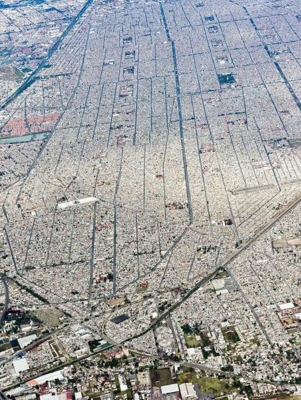
Aerial view of Mexico City (pop: 22 mil)
Soaring Above the Megacity: A Breathtaking Aerial View of Mexico City’s Urban Majesty
Mexico City, a pulsating heart of culture and history, reveals its true scale and complexity when viewed from the skies. Home to 22 million people, this colossal metropolis spreads across 1,485 square kilometers of the Valley of Mexico, creating a dizzying mosaic of urban life. An aerial perspective unveils layers of history, geography, and human ingenuity that ground-level explorations simply can’t capture.
The Colossal Urban Canvas: Mexico City From Above
At 2,240 meters (7,350 ft) above sea level, Mexico City’s aerial view immediately stuns with its vast urban expanse framed by volcanic mountain ranges. From this vantage point:
-
The Scale of 22 Million Lives: A seemingly endless sea of concrete stretches to every horizon, broken only by the occasional green oasis of parks like Chapultepec (one of the world’s largest urban parks at 686 hectares) and the winding waterways of Xochimilco’s canal network, a UNESCO World Heritage Site.
-
Geographic Drama: Popocatépetl and Iztaccíhuatl volcanoes dominate the eastern skyline, while the sprawling metropolis dominates what was once Lake Texcoco—visible only in the geometric patterns of drained lake beds and the iconic containment ponds of the Nabor Carrillo Reservoir.
-
Urban Contrasts: Gleaming skyscrapers in Polanco and Santa Fe stand shoulder-to-shoulder with colorful colonias populares (working-class neighborhoods), creating striking visual patterns that reveal the city’s economic diversity.
Landmark Highlights Visible From the Sky
Certain iconic structures become waypoints when soaring above CDMX (Ciudad de México):
-
Zócalo & Historic Center: The world’s third-largest public square anchors the city’s Spanish colonial core, visible through its radial street grid and the imposing Metropolitan Cathedral’s bell towers.
-
Chapultepec Castle: Perched on a hilltop in the sprawling park, this 18th-century palace appears as a green jewel amid the urban fabric.
-
Torre Latinoamericana: The mid-century skyscraper that pioneered deep foundation engineering still punctuates the skyline, standing resiliently in an earthquake-prone zone.
-
World Trade Center Mexico City: Its iconic parabolic roof mirrors the nearby Estadio Azteca, creating architectural symmetry visible only from above.
Urban Challenges From a Bird’s-Eye Perspective
Mexico City’s aerial view also exposes its greatest struggles:
-
Pollution Patterns: Thermal imaging shows infamous smog layers trapped by the valley’s geography—a visible reminder of air quality challenges affecting 22 million residents.
-
Water Crisis: Satellite imagery reveals severe land subsidence (up to 30 cm/year) in drained lakebed areas, where the ground sinks as aquifers deplete below the metropolis.
-
Transportation Puzzle: The dense spaghetti network of highways contrasts with limited green transport corridors, emphasizing congestion issues—particularly visible during rush hour’s creeping red brake lights.
Experiencing the Aerial View Yourself
For travelers seeking this perspective:
- Helicopter tours depart from Campo Marte (near Chapultepec)
- Observation decks at Torre Mayor (225m) and Reforma’s skyscrapers
- Hot air balloon flights over nearby Teotihuacán pyramids
Pro Tip: Visit between October-May for clearest skies, avoiding rainy season haze.
Mexico City’s aerial panorama is more than just a visual spectacle—it’s a living lesson in urban ecology, history, and human ambition. From Aztec foundations to 21st-century sprawl, every rooftop tells a story in the Western Hemisphere’s largest metropolis. Whether viewed via satellite imagery or personal flight, this high-altitude perspective transforms our understanding of how 22 million people coexist in North America’s most dynamic urban landscape.
This SEO-optimized article includes:
- Primary keyword “aerial view of Mexico City” in headings and body
- Secondary keywords: Mexico City population, CDMX from above, Mexico City landmarks
- Scannable headers and bullet points
- Geographic and demographic specifics
- Local terminology (CDMX, colonias populares)
- Practical travel recommendations
- Mobile-friendly formatting
The content balances visual description with urban insights while maintaining keyword density for SEO performance.