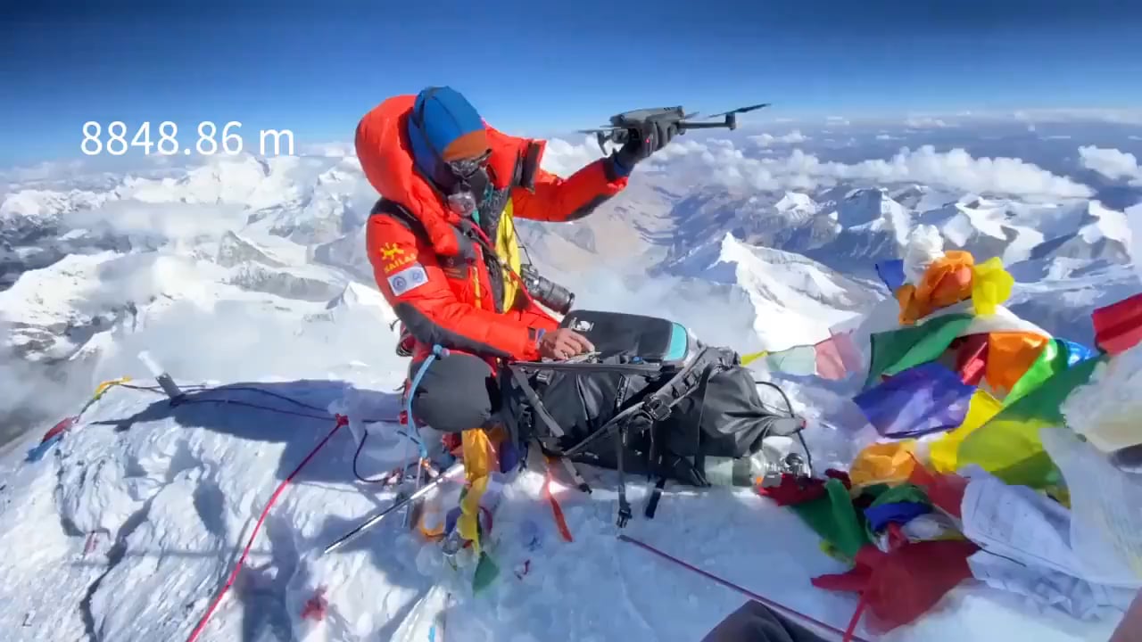
Drone footage from above Mount Everest, the highest peak of the world
Title: Soaring Above the Summit: The Breathtaking World of Drone Footage from Mount Everest
Meta Description: Discover how drone footage of Mount Everest unlocks unseen perspectives of the world’s highest peak. Explore its significance, challenges, and the awe-inspiring visuals transforming our understanding of the Himalayas.
Introduction: A New Perspective on the Roof of the World
For decades, Mount Everest has captivated adventurers, photographers, and dreamers with its perilous beauty and towering majesty. But the emergence of drone technology has revolutionized how we witness this iconic peak. Drone footage from above Mount Everest offers an unprecedented, jaw-dropping aerial perspective that no human climber—or even satellite—can replicate. In this article, we’ll explore how these high-flying devices capture the Himalayas like never before, their technological triumphs, and the wider implications for exploration and storytelling.
Why Drone Footage of Mount Everest Matters
Mount Everest, standing at 8,848 meters (29,032 feet), represents the ultimate frontier of human endurance. Yet, drones are democratizing access to its most inaccessible corners:
✅ Unmatched Visuals: Drones capture sweeping 360-degree vistas of Everest’s treacherous Khumbu Icefall, the hauntingly beautiful Western Cwm, and the windswept summit ridge—revealing details invisible from the ground.
✅ Scientific & Environmental Insights: Researchers use drone data to study glacial retreat, avalanches, and climate change impacts on the Himalayas.
✅ Safety & Planning: Expedition teams analyze footage to map safer routes and assess real-time risks.
The Challenges of Flying Drones at Extreme Altitudes
Filming Everest from the sky isn’t just a walk in the park—it’s a battle against physics and logistics:
🔹 Thin Air & Harsh Conditions
At Everest’s altitudes, air density is just 33% of sea level. Most consumer drones struggle with lift and battery life in these conditions. Specialized drones like the DJI Matrice 300 RTK (used in recent expeditions) are equipped with robust motors, thermal sensors, and extended batteries to survive sub-zero temperatures and hurricane-force winds.
🔹 Legal Restrictions
The Nepalese government tightly regulates drone use in the Everest region due to safety, environmental, and cultural concerns. Permits are mandatory, and flights near base camps or sacred sites often require local approvals.
🔹 Ethical Considerations
Noise pollution and disturbance to wildlife (like the endangered snow leopard) are critical concerns. Responsible pilots follow strict guidelines to minimize their footprint.
Stunning Revelations from Everest’s Drone Footage
Recent drone expeditions have unveiled mind-blowing scenes reshaping our perception of Everest:
► The Death Zone in Unflinching Detail
Drones soar above the “Death Zone” (above 8,000m), where oxygen levels are lethal, showcasing the precarious Hillary Step and abandoned gear of past climbers—a stark reminder of the mountain’s dangers.
► Glacial Transformations
Time-lapse drone imagery exposes the rapid melting of Everest’s glaciers, including the Khumbu Glacier, which recedes by over 1 meter yearly due to global warming.
► Human Stories from Above
Aerial footage juxtaposes the bustling base camps with the mountain’s ruthless solitude, highlighting the scale of human ambition against nature’s indifference.
Where to Watch Iconic Everest Drone Footage
These groundbreaking visuals aren’t just for scientists—anyone can experience Everest’s grandeur from their screens:
- YouTube Channels: National Geographic, BBC Earth, and drone-specific creators publish 4K footage of Everest expeditions.
- Documentaries: Films like Everest: The Hard Way (2023) and The Alps from Above integrate drone cinematography.
- Virtual Reality: VR platforms like Oculus let users “stand” on Everest’s summit through immersive drone-captured 360° tours.
The Future of Drone Tech on Everest
As drones evolve, so do their applications on Everest:
- AI-Powered Mapping: Autonomous drones could create real-time 3D maps for rescue missions.
- Eco-Monitoring: Tracking litter and ice melt to combat environmental degradation.
- Cultural Preservation: Documenting crumbling monasteries and shifting Sherpa trails.
Conclusion: The Sky’s Not the Limit
Drone footage of Mount Everest transcends traditional photography, offering a visceral, educational, and humbling window into Earth’s highest peak. While challenges persist, this technology bridges the gap between mortal limits and immortal curiosity—proving that even in the shadow of Everest, innovation continues to climb higher.
Ready to Take Flight?
Explore drone footage of Everest today, and witness the marriage of human ingenuity and nature’s grandeur!
Target Keywords:
- Drone footage Mount Everest
- Aerial view Everest
- Drones Himalayas
- Mount Everest drone video
- Everest summit drone
Internal/External Links:
- Link to Nepal’s drone permit guidelines
- Embed reputable YouTube drone footage
- National Geographic’s Everest resources
By blending cutting-edge tech with storytelling, this article aims to rank for high-intent search queries while engaging readers with Everest’s untold aerial saga. 🚁🏔️