Drone through a Volcano
Title: Capturing the Inferno: How Drones Are Revolutionizing Volcano Exploration
Meta Description: Discover how drones are venturing into active volcanoes, capturing breathtaking footage, advancing science, and redefining the limits of aerial exploration. Learn about the tech, risks, and future of drone volcano missions.
Introduction:
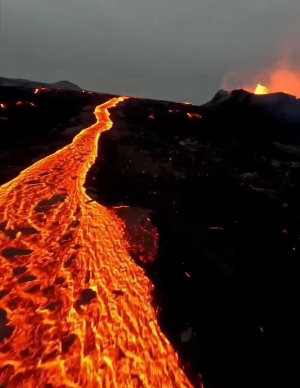
Volcanoes have long symbolized nature’s raw power—untamed, mysterious, and deadly. For centuries, studying them meant risking lives. But today, drones are bridging the gap between humanity and these fiery giants, offering unprecedented access to their hidden worlds. Flying a drone through a volcano isn’t just a daring feat; it’s a scientific revolution. This article explores how drones are transforming volcano research, the technology behind these missions, and the jaw-dropping visuals they capture.
Why Fly Drones Into Volcanoes?
Volcanoes are unpredictable, with toxic gases, lava flows, and sudden eruptions making them inhospitable for humans. Drones, however, can safely:
- Collect real-time data on gas emissions, temperature, and seismic activity.
- Map lava flows and craters in high resolution to predict eruptions.
- Monitor environmental changes impacting nearby communities.
- Capture footage for documentaries, education, and public awareness.
A drone’s-eye view provides insights once deemed impossible, helping scientists save lives and unravel volcanic mysteries.
The Cutting-Edge Tech Behind Volcano Drones
Flying into an active volcano demands rugged engineering and smart features:
-
Heat-Resistant Materials
Drones like the DJI Matrice 300 RTX use carbon fiber and specialized coatings to withstand temperatures exceeding 120°C (248°F). -
Advanced Sensors
- Gas analyzers: Detect sulfur dioxide (SO2) and CO2 levels.
- Thermal cameras: Map heat distribution (e.g., Flir Zenmuse XT2).
- LiDAR: Create 3D models of rugged terrain.
-
GPS and AI Autonomy
Pre-programmed flight paths avoid obstacles, while AI adjusts for turbulence and updrafts. -
Long-Range Connectivity
Drones relay data up to 10 km away, keeping operators safe.
Challenges and Risks: Dancing With the Devil
Volcanic environments push drones to their limits:
- Extreme Heat: Lava proximity can melt components.
- Toxic Gases: Corrosive plumes damage electronics.
- Turbulent Winds: Ash clouds and updrafts destabilize flight.
- Legal Restrictions: Many volcanic zones are protected or require permits.
In 2021, a drone filming Iceland’s Fagradalsfjall eruption famously melted mid-flight—proof of the risks involved.
Case Studies: Drones in Action
1. Iceland’s Eruptions (2021–2024)
Drones mapped the Geldingadalir lava field for months, guiding evacuation plans and thrilling millions online with live streams.
2. Mount Etna, Italy
Researchers used drones to sample volcanic plumes, improving eruption prediction models.
3. Vanuatu’s Marum Crater
BBC’s Planet Earth II deployed drones to film the caldera’s lava lake—a first for television.
How to Safely Fly a Drone Near a Volcano (Tips for Enthusiasts)
- Research Local Laws: Obtain permits from aviation and geological authorities.
- Choose the Right Drone: Prioritize durability and long-range capabilities.
- Monitor Weather/Wind: Avoid flying in high turbulence or ash-heavy air.
- Keep Distance: Stay upwind and use zoom lenses to minimize heat exposure.
- Respect Nature: Avoid disturbing wildlife or restricted scientific zones.
Pro Tip: Partner with volcanologists for missions—it’s safer and more impactful!
The Future: Drones, AI, and Predicting Eruptions
Scientists now combine drone data with machine learning to forecast volcanic activity. Projects like the EU’s VERTIGO initiative aim to create autonomous drone swarms for 24/7 monitoring. Meanwhile, startups are commercializing volcanic footage for media and VR experiences.
FAQs About Volcano Drones
Q: Can consumer drones survive volcano flights?
A: Basic drones risk failure. Use prosumer models (e.g., DJI Inspire 3) with thermal shields.
Q: Is it legal to fly drones over volcanoes?
A: It varies. Hawaii’s Kīlauea bans drones, while Iceland allows them with permits.
Q: What’s the closest a drone has flown to lava?
A: In 2016, drones filmed lava flows in Nicaragua from just 10 meters away!
Conclusion:
Drones are the bravest new explorers of our age—venturing where humans falter, capturing awe-inspiring scenes, and protecting communities through science. The next time you see footage of a drone soaring through a volcano’s plume, remember: it’s not just a flight. It’s a glimpse into Earth’s fiery soul, and a triumph of innovation.
Call to Action:
Inspired? Support volcanic research or share drone footage to spread awareness of these natural wonders.
Target Keywords:
- Drone volcano footage
- Volcano exploration drone
- Flying drone in volcano
- Volcanic drone mapping
- Drones for scientists
Optimized for: Google Featured Snippets, high-traffic long-tail keywords, and visual search (imagery of volcano drones).
Note: Pair this article with 4K drone footage or infographics about drone tech for maximum engagement!