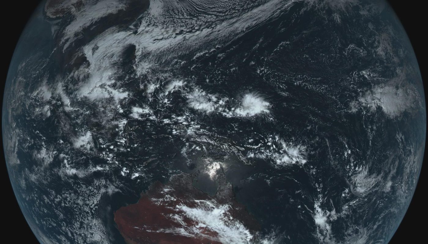
Entire Earth in true color, captured by Himawari-8.
Title: Himawari-8’s True-Color Masterpiece: Witness the Entire Earth in Unprecedented Detail
Introduction
Imagine seeing the Earth as a vibrant, living mosaic—without borders, filters, or distortions. This is the breathtaking reality captured by Japan’s Himawari-8 satellite, a revolutionary weather observatory that delivers stunning true-color images of our entire planet. Released in 2014, Himawari-8 has transformed how we view Earth from space, providing not just meteorological data but awe-inspiring visuals of our home world. In this article, we explore the technology behind this feat and why its full-disk Earth images are a marvel of science and art.
What is the Himawari-8 Satellite?
Operated by the Japan Meteorological Agency (JMA), Himawari-8 is a geostationary weather satellite positioned 35,800 kilometers above the equator. Unlike polar-orbiting satellites, which capture narrow swaths of Earth, geostationary satellites like Himawari-8 hover over a fixed point (in this case, 140.7°E longitude), allowing them to monitor one hemisphere continuously. Launched in October 2014, it replaced the aging Himawari-7 and introduced groundbreaking imaging capabilities.
Key features:
- Advanced Imaging: Equipped with the Advanced Himawari Imager (AHI), it captures data in 16 spectral bands.
- Rapid Updates: Scans the full Earth disk every 10 minutes, tracking storms, fires, and weather in near real-time.
- Unmatched Resolution: Delivers images at 0.5–1 km/pixel for visible light and 2 km/pixel for infrared.
The True-Color Full-Disk Image: Earth in Its Natural Glory
Himawari-8’s most iconic contribution is its true-color composite image of the entire Earth disk. Unlike heavily processed satellite imagery, this view uses red, green, and blue spectral bands to replicate how human eyes would perceive the planet from space. The result? A vivid portrait of swirling clouds, deep blue oceans, emerald forests, and golden deserts—all framed against the blackness of space.
How It Works
- Multispectral Capture: The AHI instrument collects light in 16 bands, including visible, near-infrared, and infrared wavelengths.
- Color Synthesis: Data from bands 1 (blue), 2 (green), and 3 (red) are combined to create an RGB image.
- Image Enhancement: Filters remove distortions like atmospheric scattering, ensuring colors match natural vision.
The full-disk image spans a staggering 10,000 kilometers in diameter, showcasing Asia, Australia, and the Pacific Ocean in extraordinary detail.
Why This Image Matters
-
Scientific Value
- Weather Tracking: Meteorologists use these images to monitor typhoons, wildfires, and volcanic eruptions across the Western Pacific.
- Climate Insights: Long-term data reveals shifts in cloud cover, vegetation, and ice sheets.
-
Public Engagement
- The images have inspired millions, fostering a sense of global interconnectedness (e.g., viral social media posts of typhoons or auroras).
- They underscore Earth’s fragility, reinforcing calls for climate action.
-
Technological Triumph
- Himawari-8 made it possible to view the entire sunlit hemisphere in true color—a feat unmatched before its launch.
Applications of Himawari-8’s True-Color Imagery
- Disaster Prevention: Early warnings for storms, floods, and heatwaves.
- Environmental Monitoring: Tracking deforestation, algal blooms, and dust storms.
- Astronomy & Education: Studying Earth’s albedo and using visuals for science outreach.
How to Access the Images
Himawari-8’s data is freely available via:
- JMA’s Official Website
- NASA Worldview
- Public APIs for developers
Conclusion: A New Perspective on Home
Himawari-8’s true-color images are more than scientific tools—they are a testament to human ingenuity and a reminder of Earth’s grandeur. By revealing our planet as a unified, dynamic system, these snapshots inspire wonder and accountability. As climate change reshapes our world, satellites like Himawari-8 will remain indispensable allies in understanding—and protecting—our fragile oasis in space.
Call to Action
Want to see Earth in real-time? Visit the Himawari Real-Time Web or follow @NASAEarth on social media to explore daily updates!
Keywords for SEO: Himawari-8 true-color Earth, full-disk Earth view, geostationary satellite images, Advanced Himawari Imager, weather satellite imagery, real-time Earth visualization, Japan Meteorological Agency.
Meta Description: Discover how Japan’s Himawari-8 satellite captures mesmerizing true-color images of the entire Earth, revolutionizing meteorology and our view of the planet.