Shipping data showing China has been coordinating thousands of fishing vessels to create floating barriers 200 miles long
China’s Maritime Strategy Revealed: How Thousands of Fishing Vessels Form 200-Mile “Floating Barriers”
Meta Description: Satellite data exposes China’s coordinated use of fishing fleets to form massive 200-mile floating barriers in contested waters. Learn how this tactic impacts geopolitics, ecology, and maritime security.
Introduction: Satellite Data Uncovers a Maritime Puzzle
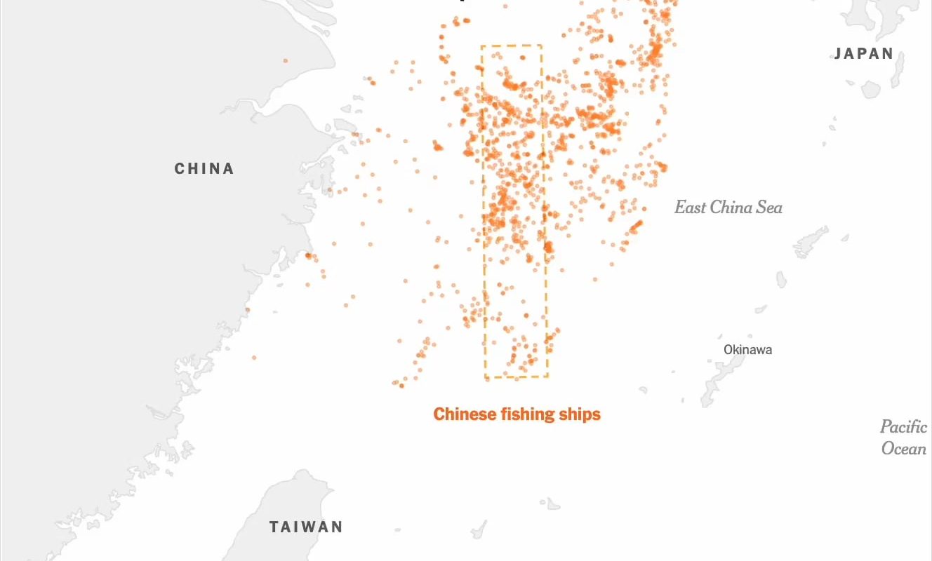
Satellite imagery and global shipping tracking systems have revealed a startling pattern in contested waters across the East and South China Seas: China is deploying thousands of fishing vessels in tightly coordinated formations, creating floating barriers stretching over 200 miles (320 km) in length. This unprecedented maritime strategy blurs the line between civilian fishing and military operations, raising alarms among neighboring nations, environmental groups, and security analysts worldwide.
Tracking the Data: How Fishing Fleets Became “Maritime Militias”
AIS Data and Satellite Imagery Reveal the Scale
Advanced Automatic Identification System (AIS) tracking, combined with commercial satellite data, shows fleets of 200–500+ fishing vessels operating in grid-like formations across strategic waterways. These fleets cluster around areas like the Spratly Islands, Scarborough Shoal, and Senkaku/Diaoyu Islands—all hotly contested territories.
Key findings from maritime analysts:
- Formation tactics: Vessels anchor in rows spaced evenly apart, blocking access to rival coast guards or fishing boats.
- State coordination: Movement patterns suggest centralized command from Chinese maritime authorities.
- Dual-use vessels: Ships often lack active fishing gear but carry supplies for sustained loitering.
Why Create a Floating Barrier? Strategic Objectives
1. Territorial Claims & Gray-Zone Warfare
China uses these fleets to assert dominance without direct military confrontation. By massing civilian vessels, it:
- Physically occupies disputed waters under the guise of “traditional fishing rights.”
- Creates legal ambiguity: International law (UNCLOS) treats fishing vessels differently from warships.
- Deters rivals: Smaller nations like the Philippines or Vietnam lack the resources to disperse such large flotillas.
2. Resource Control
Barriers often appear near oil/gas-rich seabeds or fertile fishing zones, enabling China to monopolize resources while restricting competitors.
3. Military Reconnaissance
Vessels relay real-time data to the PLA Navy, acting as a low-cost surveillance network.
Regional Reactions: Alarm and Escalations
- Philippines: Accused China of “maritime intimidation” after 220 vessels swarmed Whitsun Reef (2021).
- Vietnam: Protested fleet incursions near Vanguard Bank, a key energy exploration site.
- Japan: Increased coast guard patrols near Senkaku Islands.
- U.S. Navy: Conducts Freedom of Navigation Operations (FONOPs) to challenge China’s maneuvers.
A Vietnamese diplomat summarized the frustration:
“This isn’t fishing—it’s a floating Great Wall.”
Environmental Impact: A Crisis Beneath the Waves
These mega-fleets devastate marine ecosystems:
- Overfishing: Depletes stocks far beyond sustainable levels.
- Destructive practices: Use of cyanide, dynamite, and bottom trawling destroys coral reefs.
- Pollution: Thousands of vessels dump waste and oil into fragile habitats.
Marine biologists warn of irreversible damage to the South China Sea’s biodiversity, which hosts 3,000+ fish species.
How the World Tracks China’s Maritime Moves
- Satellites: Companies like HawkEye 360 detect AIS signals and radar emissions.
- Open-source intelligence (OSINT): Researchers cross-reference vessel registries with movement patterns.
- Diplomatic leaks: Classified reports from regional navies expose fleet coordination.
Despite China’s dismissal of accusations as “Western propaganda,” data trails consistently point to state-directed operations.
International Law: Is China Breaking the Rules?
Under UNCLOS (UN Convention on the Law of the Sea):
- ▶️ EEZ Rights: Coastal states control resources within 200 nautical miles.
- ❌ Violations: China’s fleet deployments often trespass into others’ EEZs.
Critics argue this violates the 2016 Permanent Court of Arbitration ruling, which rejected China’s “nine-dash line” claims. Beijing ignores the ruling, citing “historic rights.”
The Future: Rising Tensions and Global Implications
- Increased militarization: Rival nations may arm fishing fleets, escalating risks of conflict.
- Economic coercion: China could weaponize fleets to block trade routes in future disputes.
- Climate impact: Overfishing threatens food security for 3.7 billion people reliant on seafood.
As a U.S. Indo-Pacific Command officer warned:
“This isn’t just about fish—it’s about controlling the next geopolitical battleground.”
Conclusion: The Floating Barrier Strategy
China’s mass deployment of fishing vessels is a masterclass in gray-zone tactics—enforcing dominance while avoiding outright war. However, the environmental, legal, and security costs are immense. The world must decide whether to tolerate a maritime order where might makes right, or uphold international law before these floating barriers become the status quo.
Keywords for SEO:
China fishing fleets, floating maritime barrier, South China Sea dispute, gray-zone tactics, maritime militia, UNCLOS violations, AIS tracking data, fishing vessel coordination, South China Sea environment, PLA Navy strategy.