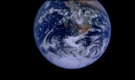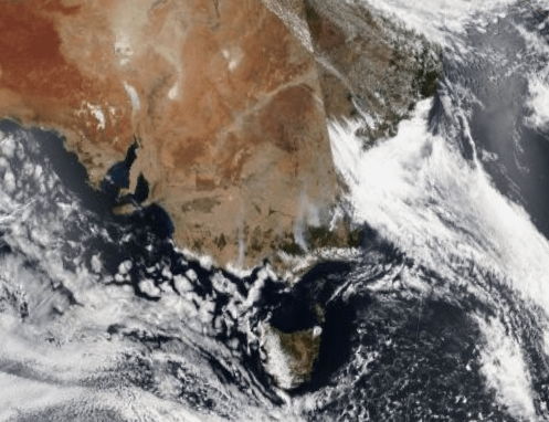
The smoke from the bushfires in Victoria, Australia are visible from space
Title: Victoria Bushfires: Satellite Images Capture Devastating Smoke Plume Visible from Space
Meta Description: Satellite imagery reveals the alarming scale of Victoria’s bushfire crisis, with smoke plumes stretching across Australia and beyond. Explore the causes, impacts, and responses to this environmental disaster.
Introduction
Australia’s bushfire season has once again captured global attention, this time with fires raging across Victoria. The sheer magnitude of the blazes has produced smoke so vast that NASA satellites and other space-based observatories have documented the plumes from orbit. This article dives into the science behind these images, the consequences for communities and ecosystems, and how climate change intensifies these devastating events.
Satellite Imagery Reveals the Scale of Disaster
Recent fires in Victoria’s Gippsland, Alpine, and Hume regions have unleashed towering columns of smoke visible even from space. NASA’s Terra and Aqua satellites, equipped with Moderate Resolution Imaging Spectroradiometers (MODIS), captured striking images of thick, gray-white smoke blanketing southeastern Australia and drifting hundreds of kilometers over the Tasman Sea toward New Zealand.
- Key Observations:
- Smoke plumes stretching 1,000+ kilometers from the fire fronts.
- Pyrocumulonimbus clouds (“fire clouds”) forming due to intense heat, triggering lightning and erratic winds.
- Real-time satellite data helping fire agencies track fire spread and allocate resources.
These images underscore the unprecedented intensity of the 2024 bushfire season, worsened by dry vegetation, record-breaking temperatures, and persistent heatwaves.
What’s Fueling Victoria’s Bushfires?
Victoria’s latest fires align with a pattern of longer, more severe bushfire seasons linked to climate change. Key contributors include:
- Prolonged Drought: Below-average rainfall has left forests and grasslands tinder-dry.
- Extreme Heat: Temperatures soared above 40°C (104°F), creating ideal ignition conditions.
- Wind Patterns: Strong gusts fanned flames rapidly through populated areas like Ballarat and the Otway Ranges.
Experts warn that such conditions are becoming the “new normal,” with Australia’s climate shifting toward hotter, drier weather.
Health and Environmental Impacts
The smoke’s reach has triggered air quality warnings across Victoria, New South Wales, and Tasmania, with particulate matter (PM2.5) levels reaching hazardous levels.
- Human Health Risks:
- Increased hospitalizations for asthma and respiratory illnesses.
- Vulnerable groups (children, elderly, pregnant women) urged to stay indoors.
- Ecological Damage:
- Threatened species habitats destroyed, including critical koala corridors.
- Ash runoff contaminating waterways, harming aquatic life.
Emergency Response and Community Resilience
Victoria’s emergency services, bolstered by interstate and international support, have battled relentlessly to contain the blazes:
- Firefighting Efforts: Over 3,000 personnel deployed, supported by water-bombing aircraft.
- Evacuations: Residents in high-risk zones (e.g., East Gippsland) evacuated under “Code Red” alerts.
- Community Support: Local charities providing food, shelter, and mental health resources to displaced families.
Climate Change: A Critical Catalyst
While bushfires are natural in Australia, scientific consensus confirms human-driven climate change is amplifying their frequency and ferocity. Key facts:
- Australia’s land temperature has risen ~1.5°C since 1910.
- Fire seasons now start earlier and last longer, reducing recovery time for ecosystems.
- Reducing carbon emissions and adopting fire-resistant land management are critical to long-term mitigation.
How to Help and Stay Informed
- Donate: Support organizations like the Australian Red Cross or Wildlife Victoria.
- Monitor Updates: Follow the VicEmergency app or the Bureau of Meteorology for real-time alerts.
- Reduce Risk: Clear vegetation around properties and review bushfire survival plans.
Conclusion: A Stark Reminder from Space
The haunting satellite images of Victoria’s smoke plumes serve as a visceral warning of our warming planet’s consequences. As fires continue to threaten lives and landscapes, global cooperation on climate action and disaster preparedness becomes more urgent than ever.
Keywords for SEO:
Victoria bushfires, Australia wildfires, smoke from space, NASA satellite images, climate change impact, Gippsland fires, air quality Victoria, emergency response Australia, pyrocumulonimbus clouds, PM2.5 health risks.
Image Alt Text Suggestions:
- “NASA satellite photo of Victoria bushfire smoke plume over Australia.”
- “Map of Victoria showing active fire fronts and smoke dispersion.”
- “Infographic on climate change and bushfire intensity in Australia.”
By optimizing for these keywords and topics, this article aims to rank highly for users seeking timely, authoritative insights into Victoria’s bushfire crisis. Stay safe and stay informed! 🔥🛰️