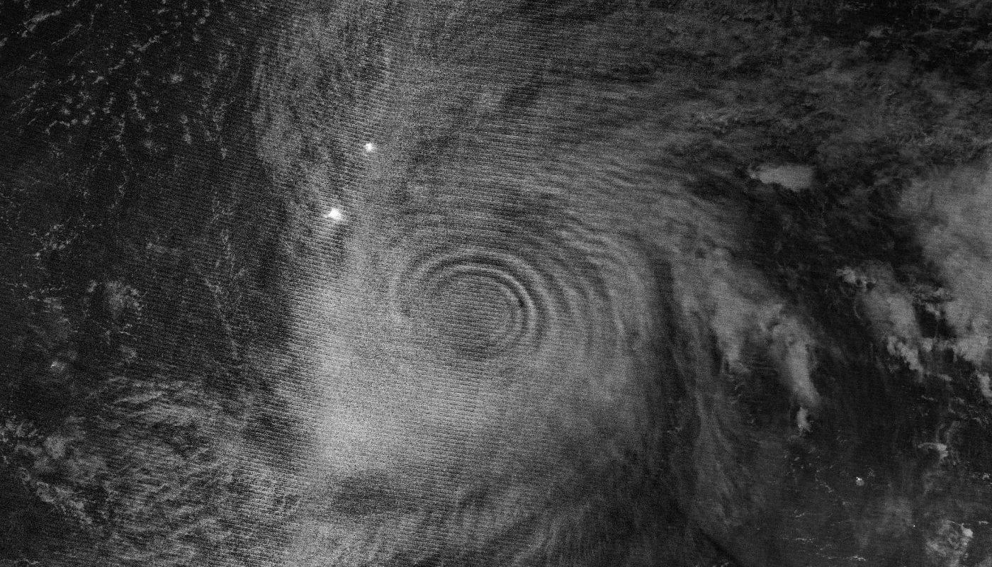
NASA captured atmospheric gravity waves from Super Typhoon Sinlaku spreading through the upper atmosphere
Imagine being able to see the ripple effects of a powerful storm spreading through the atmosphere like a stone cast into a still pond. That’s exactly what NASA captured recently – the atmospheric gravity waves from Super Typhoon Sinlaku as they spread through the upper atmosphere. It’s a breathtaking sight that not only showcases the raw power of nature but also gives us a glimpse into the complex dynamics of our atmosphere. The images, which resemble a series of concentric circles or a vast, atmospheric “bullseye,” are both mesmerizing and humbling, reminding us of the awe-inspiring forces that shape our planet.
Understanding Atmospheric Gravity Waves
Atmospheric gravity waves are essentially ripples in the atmosphere that occur when there is a disturbance, such as a storm, that displaces air. These waves can travel long distances and affect the atmosphere at various levels, from the lower atmosphere where weather occurs to the upper atmosphere where the air is much thinner. The capture of these waves from Super Typhoon Sinlaku by NASA is significant because it provides scientists with valuable data to study these phenomena. By analyzing these waves, researchers can gain insights into the dynamics of the atmosphere and how different weather systems interact with each other and with the environment.
The Science Behind the Capture
The technology used by NASA to capture these atmospheric gravity waves is incredibly sophisticated. It involves using satellites equipped with specialized instruments that can detect even the slightest changes in atmospheric conditions. These instruments can measure changes in air pressure, temperature, and wind speed, which are all crucial factors in understanding how atmospheric gravity waves propagate. The data collected from these satellites is then analyzed using advanced computer models that can simulate the behavior of the atmosphere under various conditions. This combination of observational data and computational power allows scientists to study atmospheric phenomena in unprecedented detail, providing new insights into the workings of our atmosphere.
Implications for Weather Forecasting and Climate Science
The study of atmospheric gravity waves has important implications for both weather forecasting and climate science. By better understanding how these waves interact with different weather systems, scientists can improve the accuracy of weather forecasts. This is particularly important for predicting the behavior of severe weather events like typhoons, hurricanes, and storms, which can have devastating impacts on communities. Additionally, the study of atmospheric gravity waves can also provide insights into the dynamics of the upper atmosphere, which is crucial for understanding climate change. As we continue to learn more about these fascinating phenomena, we may uncover new ways to predict and mitigate the effects of severe weather and climate change, ultimately helping us to better protect our planet and its inhabitants.
The capture of atmospheric gravity waves from Super Typhoon Sinlaku by NASA is a remarkable achievement that highlights the complexity and beauty of our atmosphere. As we continue to explore and understand these phenomena, we are reminded of the incredible forces that shape our world and the importance of ongoing research into the dynamics of our atmosphere. With each new discovery, we are one step closer to unlocking the secrets of the atmosphere and better understanding our place within the larger cosmos.